
UTILIZING GIS, RS, AND AHP METHODOLOGIES FOR ADAPTIVE FLOOD RISK MAPPING IN OVIA-NORTH EAST LOCAL GOVERNMENT AREA, EDO STATE, NIGERIA.
DOI:
https://doi.org/10.60787/tnamp.v20.381Keywords:
Flood risk, Multi-Criteria Analysis, Geographic Information System, Analytical Hierarchy ProcessAbstract
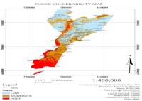
Flooding due to excessive rainfall is a frequent and widely reported disaster. This study aims to create flood risk maps for public use and estimate the likelihood of flooding in rapidly urbanizing areas. An integrated Analytical Hierarchy Process (AHP) and Geographic Information System (GIS) approach was used to model flood risk zones. A spatial decision support system analyzed flood risks, utilizing datasets such as high-resolution satellite images, SRTM DEM data, FAO soil data, and rainfall data. Flood-enhancing elements, including vulnerability mapping, were created in GIS at a 1: 400,000 scale. This multi-parametric approach considered factors such as rainfall distribution, elevation, slope, drainage network, land use, and soil type. The output raster maps were ranked using the Weighted Linear Combination method and analyzed via Multi-Criteria Analysis (MCA), with a consistency ratio of 0.037 confirming the model's validity. The study identified topography and rainfall as significant contributors to flood risk
Downloads
References
Nasiri, H., Mohd, J.M.Y., Thamer, A.M.A. (2016). An overview to flood vulnerability assessment methods. Sustainable Water Resources Management, 2, 331–336.
Sarkar, D., Mondal, P. (2020). Flood vulnerability mapping using frequency ratio (FR) model: a case study on Kulik river basin, Indo-Bangladesh Barind region. Applied Water Science, 10(1), 17.
Erena, S.H., Worku, H. (2018). Flood risk analysis: causes and landscape-based mitigation strategies in Dire Dawa city, Ethiopia. Geoenvironmental Disasters, 5(1), 16.
Ali, S.A., Khatun, R., Ahmad, A., Ahmad, S.N. (2019). Application of GIS based analytic hierarchy process and frequency ratio model to flood vulnerable mapping and risk area estimation at Sundarban region, India. Modeling Earth Systems and Environment, 5(3), 1083–1102.
Indrayani, P., Mitani, Y., Djamaluddin, I., Ikemi, H. (2018). Spatial-temporal vulnerability and risk assessment model for urban flood scenario. ASM Science Journal, 11(Special Issue 3), 233–245.
Panhalkar, S.S., Jarag, A.P. (2017). Flood risk assessment of Panchganga River (Kolhapur district, Maharashtra) using GIS-based multicriteria decision technique. Current Science, 112(4), 785.
Wei, C., Haoyuan, H., Shaojun, L., Himan, S., Yi, W., Xiaojing, W., Baharin, B.A. (2019). Flood susceptibility modelling using novel hybrid approach of reduced-error pruning trees with bagging and random subspace ensembles. Journal of Hydrology, 575, 864–873.
Hong, H., Panahi, M., Shirzadi, A., Ma, T., Liu, J., Zhu, A.X., Chen, W., Kougias, I., Kazakis, N. (2018). Flood susceptibility assessment in Hengfeng area coupling adaptive neuro-fuzzy inference system with genetic algorithm and differential evolution. Science of the Total Environment, 621, 1124–1141.
Cao, C., Xu, P., Wang, Y., Chen, J., Zheng, L., Niu, C. (2016). Flash Flood Hazard Susceptibility Mapping Using Frequency Ratio and Statistical Index Methods in Coalmine Subsidence Areas. Sustainability, 8, 948.
Pilon, P.J. (Ed.). (2004). Guidelines for reducing flood losses. New York: ISDR.
Wisner, B., Blaikie, P., Cannon, T., Davis, I. (2004). At risk: Natural hazards, people’s vulnerability and disasters. New York: Routledge.
Sofia, G., Roder, G., Dalla Fontana, G., Tarolli, P. (2017). Flood dynamics in urbanized landscapes: 100 years of climate and human’s interaction. Scientific Reports, 7, 40527.
Alho, P., Sane, M., Huokuna, M., Käyhkö, J., Lotsari, E., Lehtiö, L. (2008). Mapping of floods. Environmental Administration Guidelines, 2, 59-101.
Izinyon, O.C. (2018). Flood Hazard Modelling and Management. A paper presented in one of the technical sections of the Nigeria Society of Engineers, 1-16.
Klijn, F. (2009). Flood risk assessment and flood risk management: An introduction and guidance based on experience and findings of FLOOD site (an EU-funded Integrated Project). Delft: Deltares, Delft Hydraulics.
Ehiorobo, J.O., Izinyon, O.C., Ilaboya, I.R. (2012). Effects of Climate Change on River flow regimes in the Mangrove and Tropical Rain Forest Region of West Africa. Presented at an International Workshop on Exchange of Experience in Water Resources Management Between Europe/China/Africa/Latin America, 15–18 October, 2012. Organized by European Commission Joint Research Centre, ISPRA, Italy.
Kundzewicz, Z.W., Piniewski, M., Mezghani, A., Okruszko, T., Pińskwar, I., Kardel, I. (2018). Assessment of climate change and associated impact on selected sectors in Poland. Acta Geophysica, 66(6), 1509–1523.
Bloschl, G., Hall, J., Parajka, J., Perdigao, R.A.P., Merz, B., Arheimer, B., Aronica, G.T., Bilibashi, A., Bonacci, O., Borga, M. (2017). Changing climate shifts timing of European floods. Science, 357, 588–590.
Gebrehiwot, A.A., Hashemi-Beni, L. (2021). Three-dimensional inundation mapping using UAV image segmentation and digital surface model. ISPRS International Journal of Geo-Information, 10, 144.
ISDR (International Strategy for Disaster Reduction). (2004). Living with risk: A global review of disaster reduction initiatives. Geneva: ISDR.
ISDR (International Strategy for Disaster Reduction). (2007). Disaster risk reduction: A global review 2007. Geneva: ISDR.
Matej, V., Vojteková, J. (2019). Flood Susceptibility Mapping on a National Scale in Slovakia Using the Analytical Hierarchy Process. Water, 11(364), 1-17.
Al Baky, M.A., Islam, M., Paul, S. (2019). Flood hazard, vulnerability and risk assessment for different land use classes using a flow model. Earth Systems and Environment, 4, 1–20.
Hoque, M.A.-A., Tasfia, S., Ahmed, N., Pradhan, B. (2019). Assessing spatial flood vulnerability at Kalapara Upazila in Bangladesh using an analytic hierarchy process. Sensors, 19(6), 1302.
Mundhe, N. (2019). Multi-criteria decision making for vulnerability mapping of flood hazard: a case study of Pune city. Journal of Geographical Studies, 2(1), 41–52.
Cafiero, C., Vakis, R.N. (2006). Risk and vulnerability considerations in poverty analysis: recent advances and future directions. World Bank, Social Protection, Washington.
Singh, L.K., Jha, M.K., and Chowdary, V.M. (2017). Multi-criteria analysis and GIS modeling for identifying prospective water harvesting and artificial recharge sites for sustainable water supply, J. Clean. Prod., 142, 1436–1456
Saaty T. L. (1980), The Analytic Hierarchy Process, McGraw-Hill, New York., 67-78
Bui, D.T., Shahabi, H., Alizadeh, M., Ahmad, B.B., Samui, P., Ho, L.S., & Panahi, M. (2019). Spatial prediction of rainfall-induced landslides using a hybrid machine learning approach based on Random Subspace and Classification and Regression Trees. CATENA, 175, 203-213. DOI:
1016/j.catena.2018.12.018.
Tehrany, M.S., Pradhan, B., & Jebur, M.N. (2015). Flood susceptibility mapping using GIS-based support vector machine and frequency ratio models in Tehran province, Iran. Journal of Hydrology, 528, 240-252. DOI: 10.1016/j.jhydrol.2015.06.028
Downloads
Published
Issue
Section
License
Copyright (c) 2024 The Transactions of the Nigerian Association of Mathematical Physics

This work is licensed under a Creative Commons Attribution-NonCommercial 4.0 International License.